 The Thousand Islands, 1650-1850: A Study in Exploration,
Settlement, and Development The Thousand Islands, 1650-1850: A Study in Exploration,
Settlement, and Development
By Brian S. Osborne Original Manuscript Copyright ©1976 by Parks Canada. Reproduced by permission of St. Lawrence Islands National Park.
Table of Contents Introduction Abstract
The region is defined not only in terms of the islands but also in terms of its location athwart a major corridor of movement and in an area of early and significant settlement. Three elements may be taken as constituting the Thousand Islands region, therefore:
The period of the study is also distinctive as it is associated with the following processes:
The emphasis in this study will be upon the impact of human activities upon the land and the resultant landscape produced by the settlement process. Reference will be made to the initial contact and discovery of the region, the introduction of settlers into it, and the processes of economic and social development during the two centuries of the study period.
The nature of the physical environment is of importance in this region because its unique beauty and setting imparts one of the characteristic features of the region. But it is also of some import as the setting in which the settlement process and economic development of the area took place. The environment of the Thousand Islands region will be considered in the following contexts:
The introduction of a population of European origin into the region was related to considerations of foreign politics, commerce, and ideology at various periods in the history of this area. Three main periods may be recognized, each with its own associated cultural, demographic and economic attributes: 1. The French, 1650-1763. While it was the French who first discovered and utilized the Thousand Islands region, their activities were confined to the river itself and to two principal localities, one at each end of the region:
The French left little evidence of their presence throughout the region although vestiges rnay be recognized in certain names, and the sites selected by the ensuing settlers were often associated with the clearings effected by their French predecessors. 2. The Loyalists, 1763-1815. One of the dominant characteristics of the Thousand Islands region is its heritage as a core area of settlement by the displaced loyalists in 1783. For twenty years following the defeat of the French, the British presence was titular only, although there was some activity around Carleton Island. The arrival of the Loyalists as settlers in 1783 was the overture to the process of permanent settlement. The following themes will be considered:
3. The Upper Canadians, 1815-1851. Following the 1812-1815 war, while the essential cultural attributes of the region continued to be those of the Loyalist heritage, the dominant themes in the region's activities were those related to the progress of the economy. It is in these years that the mature society and commercial agricultural economy was attained. Reference will be made to the following:
The above, therefore, constitute the major processes and events in the history of the region during the study period, and it is of some interest to see to what extent the landscape evinces certain of the identified themes. Attention will be directed towards the following themes:
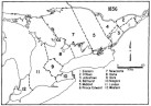
Introduction [Top] The Thousand Islands region has long been recognized as a distinctive segment of North America. It is a composite of three constituents which together make the region unique: the river, the adjacent littoral, and the islands themselves. While much of the early attention of the European colonial powers was focussed upon the river as a corridor of movement into the interior, the settlement of the adjacent lands to the north and south soon became a concern of some importance to the emerging nations on either side of the river. As for the islands, while they were frequently referred to because of their beauty, they were for long witheld from settlement, and generally passed over. It was not until the second half of the 19th century that they were to become of some importance to the region. It is because of this heritage of early European contact and the unique beauty of the river, shore, and islands, that the Thousand Islands region constitutes a resource of some interest to contemporary society. For the purposes of this study, therefore, the region is taken as being the northern shore of the St. Lawrence from Pittsburgh Township in Frontenac through the townships of Leeds and Lansdowne, Escott, Yonge, and Elizabethtown in Leeds County; on the southern shore, the region includes Jefferson and St. Lawrence counties.  Figure 1: Modern Political Boudaries Figure 1: Modern Political BoudariesThe period of this study, 1650-1850, is also distinctive. The opening date may be associated with the first penetration of the region by the French. The ensuing two centuries witnessed the development of some degree of military, mission, and commercial interest in the area by the French, and more considerable settlement of the region by the British and Americans on the north and south shores respectively. During these two hundred years, contact with the region intensified as traffic through the region increased and as permanent settlement throughout the region progressed. The closing date, 1850, is associated with the advent of significant developments in the region. By this date, the settlements had achieved some degree of maturity, the agricultural economy was beginning to shift from the staple of wheat to the specialization in livestock and dairying, while the emergence of urban centres and industrial activities were beginning to add a new dimension to the character of the region. Moreover, of some significance to the islands themselves, the second half of the 19th century witnessed the development of a formal recreational and tourist industry and thus opened up a new period of commercial development for the whole region. Given these constraints of region and period, therefore, the theme of this paper will be the impact of people upon the land in this region and their changing relationship with the environment and resource base. The landscape of the Thousand Islands is a visible record of this process and contains vestiges of past peoples, processes, and events in the settlement history of the region. In particular, reference will be made to the initial contact and discovery of the region, the introduction of settlers, and the process of economic and social development during the two centuries of the study period. The Land [Top] The nature of the physical environment of the Thousand Islands and surrounding lands is of some importance in understanding the region because its unique beauty and character imparts one of the essential features of the region. Moreover, it is also of importance as the setting in which the settlement process and economic development of the area took place. The first concern of any group of settlers on entering a new area is evaluating the nature of the host environment. Later, improved technology and the possibilities for commercial diversification may free them to some extent from the environmental control but at the initial state of pioneer contact, the constraints on productivity are crucial. In this connection, the dominant controlling element of the environment of the Thousand Islands region is, and was, the Frontenac Axis, an extension of the Canadian Shield which crosses the St. Lawrence in the Kingston-Brockville region. Dominated by black to green gneisses and schists with bosses of granite and syenite, the characteristic topography is hilly with a series of ridges alternating with poorly drained, marshy depressions. To the east and northeast, these Precambrian outcrops are overlain by Cambrian and Ordovician limestones and sandstones in the townships of Elizabethtown, Kitley, and Bastard. This basic pattern of the underlaying geology has, in places, been obscured by past glacial activity in the area. Thus, the Precambrian rocks are frequently masked by a mantle of glacial clay which constitutes an extensive glacial plain interrupted by outcropping bosses of rock. In the area of the Ordovician limestone plain, the soils are usually more thin, although ridges of deep, loamy till do occur (Gillespie et al, 1968). With regard to vegetation and land use, mixed deciduous-coniferous woodland interspersed with swamps and marshes occur throughout the Precambrian area, while the more regular topography of the sandstone and limestone areas exhibits more improved and clutivated land. These same contrasts may also be observed throughout the islands. But what was the face of the land three centuries ago at the time of the initial European contact with the area? The present landscape, even what now may appear to be unmodified sections of it, has been affected by the exploitation and consequent modification at the hands of settlers and developers of the primary resources. The reconstruction of the original environment, however, is of some academic interest in its own right because it is related to the better understanding of the settlement process, which was much influenced by the contemporary perception of the environmental groundplan. One of the first Europeans to provide us with an evaluation of the lands along the St. Lawrence was Frontenac who, in 1673, reported to Colbert that at the site of the proposed fort at Cataraqui:
An interesting ensuing commentary upon the qualities of the lands of the area is to be found in a French map, dated 1680, entitled Carte d'une Grande Partie du Canada, in which the Thousand Islands, while not named, are clearly depicted and the lands adjacent to them are described as follows:
The western terminus of the region is also commented upon as the area where "les plus grande bastimens peuvent naviguer d'icy iusque au bout du lac frontenac". But other than these and similar general comments, we know but little of the French evaluation of the lands throughout the region (see Hough, 1880). Twenty years after the British displaced the French from the area, in the summer of 1783, Governor-General Haldimand initiated the exploration and survey of the lands to the west of Montreal, which had been designated as a reception area for the displaced Loyalists from the American colonies. Holland, the Surveyor-General of Québec, reported to Haldimand that:
While a survey later that year confirmed that the eastern portion of the Thousand Islands region "would admit of a tolerable Good Settlement", the land in the western section, to the east of Cataraqui, was "exceeding bad, being a constant succession of stoney Ledges and sunken swamps altogether unfit for Cultivation, for 3 miles at least back from the Lake" (Cruikshank, 1934). A more propitious evaluation was forthcoming from Captain Justus Sherwood who, in 1783, reported that in terms of the general quality of the selected area:
For the period of British contact, the records and reports of the early surveyors of the lands are invaluable. Not only did they survey the metes and bounds of the townships, concessions and lots, but they were also concerned with effecting an inventory of the resources of the area. These surveyors were required to determine and record in their journal "whatever is observable for its singularity and value, towards the public utility, as ... the quality of the lands, and timber, etc.". (Gentilcore and Donkin, 1973). While the implementation of these recommendations varied from surveyor to surveyor and township to township, these journals do allow us some insight into the character of the "New Land" at the time of the first development for settlement. Thus, it was generally reported of the front townships that "The good Lands in this Township are all similar, Timbered with Beech Maple and Bass and the Swamps are Cedar Ash & Tamarack" (Lands and Survey, Sherwood, 1811). While surveyor Aitken abandoned his survey of Pittsburgh township in 1792 because the land was so bad that "I would be putting Government to a useless expense to Survey lands that never will be settled" (Lands and Surveys, Aitken, 1792), and while the surveyor of Leeds and Lansdowne in 1791 "Could not continue the line with any degree of certainty in so mountainous a Country" (Lands and Surveys, Pennoyer, 1791), the more general pattern throughout the front townships was that of extents of "Good Land" interspersed with "ridges and swails". While most of the surveyors' evaluations were principally concerned with identifying the potential of the area for agricultural settlement and the exploitation of timber resources, reference was also made to other attributes. In particular, the surveyors of both Pittsburgh and Yonge reported the existence of local magnetic anomalies which they attributed to "Iron Ore lodged in the rock" (Lands and Surveys, Grant, 1974; Sherwood, 1807). Sherwood also commented on the fauna of Pittsburgh township and reported that:
Blackflies and mosquitoes were also abundant and such laconic entries in the surveyors' notes as "the flies came and we were glad to have it rain to beat them off" or again, "All hands obliged to lay still on the account of the flies", will strike a sympathetic note with present-day visitors to the bush country. Further detail is added to this picture of the environment in the early years of settlement by the comments of early travellers and visitors to the region. A particularly detailed and well-informed statement of the character of the area is to be found in Gourlay's Statistical Account of Upper Canada (Gourlay, 1822). His evaluation of the western part of the Thousand Islands region again emphasized the ruggedness of the front sections of the townships of Pittsburgh, Leeds and Lansdowne:
In the interior of Leeds and Lansdowne, however, the conditions were noted to improve and the capabilities of the soil for agriculture were more favourably reported on:
Similar conditions were found to prevail in Elizabethtown, although there were thought to be more extensive areas of productive land:
 

Other 19th century travellers through the region made similar observations upon the general character of these lands facing the St. Lawrence in the Thousand Islands region. Gourlay also commented upon the environment of the islands themselves and, in particular, the state of development and salubrious climate attributed to them:
Prosaic though Gourlay's comments may appear to be, it is interesting that other early observers paid even less attention to the islands. In 1805, Boulton referred briefly to "Grenadier Island, which lies in front of this township, as do several other small ones" and to "Howe Island (which) lies partly in front of this township, as do several small islands". Furthermore, Heriot (1807), Houchette (1815) and Hall (1818) make no reference to the islands. As the century progressed, however, and as the traffic through the area increased, descriptions of the Thousand Islands became more detailed and frequent. In 1842, Bonnycastle devoted a chapter to the islands and is moved to excesses in describing their beauty:
Here nature appears to have used her utmost fancy in preparing a grand proscenium to feast the wanderer's eye, ere it reaches the vast open seas of fresh water which he is about to launch out upon.... Most of the Thousand Islands are covered with dense masses of forest trees; and some of these woody isles, low and flat, give the idea of the tranquil scenes of an Italian lagoon, as seen in the heated, but pure atmosphere and sky of a Canadian autumn; others are split and rent into a variety of fantastic forms, and present views of singular wildness: again, at another turn of the labyrinthine channel, we pass under a frowning wall of precipitous rock, covered with the moss and lichens of ages, and on whose bare tops, where never yet has man set his foot, the hoary pine or fir lifts its proud dark head, supported only by the finger like fibres of which its few, but firmly clasping bare roots are formed. Then, again, another fairy picture presents itself, in groves growing, as it were, out of the water, and apparently stopping all further progress; whilst, in a single second, the verdant curtain is drawn, and the eye wanders over a vast tract of rippling water, broken, here and there only by a few small rocks projecting above its surface, and bounded by the ancient and interminable forests of the main land. (Bonnycastle, 1842). By the mid-century, the Thousand Islands had become one of the sights to be seen en route west by those taking the "Grand Tour" of the continent. C.R. Weld's commentary on the character and potential of the islands is both representative and perspicacious:
This, therefore, was the physical setting for the settlement and development of the Thousand Islands region and the way it was perceived by early commentators. It is a point worthy of comment that if the emphasis was often placed upon the inimical evaluations of the agricultural potential in the first half of the 19th century, it was the general ruggedness and wild nature of the islands and adjacent shores which attracted so much favourable comment in later years and which was to constitute a resource in the second half of the century. The People [Top] The introduction of a population of European origin into the region was related to external conditions. The current mercantilism of the European powers, the territorial expansionism of European nation states, and the missionary zeal of the contemporary church all resulted in an infusion of peoples and their associated institutions into the Thousand Islands region. Three main periods may be recognized, each with its associated cultural, demographic and economic attributes:
While it was the French who first discovered and utilized the Thousand Islands region, their activities were confined to the river, a concentration of interest which reflected their concern with matters fundamentally external to the region. Thus, prior to the mid-17th century, French Canada was very much focussed on the Quebec-Montreal axis and the lands upstream from Montreal were little known. The second half of the 19th century witnessed the expansion of the sphere of influence of the French into the Great Lakes region and it was during this period that the St. Lawrence region experienced its first contact with the French. The latter recognized the potential importance of the region as a corridor of movement into the interior and certain sites, in particular Cataraqui, were developed because of their commercial and strategic significance. By the commencement of the 18th century, political conflicts over territorial claims in the interior of the continent between Britain and France added a new dimension to the significance of the St. Lawrence - Great Lakes region in general and the Thousand Islands region in particular. Fortifications and military operations were added to the activities of the existing centres of French settlement (Eccles, 1964, 1969).  Figure 4: Eastern North America after the Quebec Act, 1774 Figure 4: Eastern North America after the Quebec Act, 1774The continued significance of the St. Lawrence as a corridor of movement for the French in their drive to the west in pursuit of the fur trade, and in their expansion of the bounds of "New France" resulted in a progressively more detailed knowledge of the Thousand Islands region and its environs. The earliest attempt at depicting the lands to the west of Montreal was Samuel de Champlain's Carte geographigue de la Nouvelle Franse faiette par le Sieur de Champlain Saint Tongois Cappitaine Ordinaire pour le Roy en la Marine, dated 1613. Intended to depict the results of the voyages of exploration between 1608 and 1611, the representation of the lands upstream of Montreal was derived from information obtained from the native peoples of the area and was not the result of first-hand observation. However, an archipelago was recorded at the junction of the upper reaches of the St. Lawrence where it emerges from the Great Lakes, in the general vicinity of the Thousand Islands. Later voyages by Champlain confirmed their existence and Frontenac, on his expedition to Cataraqui in 1673, reported in his journal:
From this period of permanent occupation of the upper St. Lawrence and Great Lakes, the cartographic representation increased in volume and achieved greater accuracy. Thus, a map of 1670 entitled Carte du Lac Ontario et des habitations qui l'environment and produced by the missionaries Dolier and Galine clearly depicts an archipelago in the upper St. Lawrence which they named "Ilets de roche". In 1680, the Carte d'une Grande Partie de Canada again represents the islands and "Isle Ganonkouenot ou Bade" (Wolfe Island) opposite the location of "Katarakouay ou Frontenac". Then, in 1686, the first specific reference to the Thousand Islands is made in a map by the hydrographer Jean Deshayes which identifies the "Lac des Milles Illes". From this date, the ensuing maps of Raffeix, Franquelin, de Levy, d'Anville, etc..., depict the islands in ever-increasing detail although as late as the close of the 18th century, certain maps still erroneously referred to the upper St. Lawrence as the River Cataraqui or even the Iroquois River. 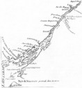 Figure 5: Le Fleuve Saint-Laurent, 1755 Figure 5: Le Fleuve Saint-Laurent, 1755But while the knowledge of the general delineations of the region was increasing, actual settlement was sparse and concentrated at two principal localities which were to be the dominant nodes of French activity throughout their period of control of the Thousand Islands region.
At the north-western end of the region, at the junction of the St. Lawrence with Lake Ontario, the French established a fort and settlement which was to be the most significant centre of French influence in the region in terms of both the extent and duration of occupance. Remy de Courcelle had reconnoitered the site in 1670 and this initial contact was followed, in 1673, by the establishment of a fort at Cataraqui by Governor Frontenac. Intended to oversee the fur trade in general and the Iroquois in particular, the fort was accompanied by some settlement and agriculture with the original seigneurial rights and privileges being awarded to La Salle. A 1682 description referred to the extent of the cleared land and recorded that "There are quite near the fort several French houses, an Iroquois village, a convent and a Recollet church" (Preston and Lamontagne, 1958; Stewart and Wilson, 1973; Mackenzie, 1967, 1973). From 1676-1679, Father Hennepin was a missionary at the site and his description of this, the earliest European settlement in the region, is of some interest:
While the fort was abandoned in 1689, it was later restored by the French with a major fortification, Fort Frontenac, being constructed as part of the line of fortifications against the British (Eccles 1964; 1969, Stewart and Wilson, 1973). At the time of its capture by the British in 1758, the significance of this settlement may be measured by the materiels captured and destroyed. Indeed, when visited by Rogers in 1760, it was noted that there were over 500 acres of land that had been cleared by the French, a fact which was to influence events a generation later (Jones, 1946).
This area of French presence and influence spans the Ogdensburg-Maitland region and is associated with a later period of French contact. It was not until 1748 that Father Piquet established the mission and fort at La Presentation on the site of the present-day Ogdensburg. The occupation of the mission site commenced with the felling and milling of "trees of prodigous size and height". (O'Callaghan, 1851) and the construction of a nucleus of building on this site at the mouth of the Oswegatchie River. With the fall of Fort Frontenac in 1758, a brief period of intensified development was focussed upon this region. The need for a base for shipbuilding and military operations on the upper reaches of the river and Lake Ontario resulted in the establishment of a fort and shipyards at Point au Baril, sometimes referred to as Point au Pins, at the site of present-day Maitland. Furthermore, with the threatened advance of the British, the new fortification of Fort Levis was constructed downstream from La Presentation at Isle Royale, now known as Chimney Island. The capture of the defences at Point au Baril and Isle Royale in 1760 terminated the French presence in the region and, indeed, constituted the last military action against the French in the St. Lawrence valley (Mackenzie, 1967, 1973; Leavitt, 1879). In summary, therefore, it may be observed that despite much commercial, spiritual, and military enterprise throughout the region, the French left but little evidence of their presence. After all is said, the total French population in "New France" was only 70,000 and was dispersed from the Atlantic, along the St. Lawrence, through the Great Lakes, and down the Mississippi to the Gulf of Mexico. It is not surprising, therefore, that their demographic impact upon the Thousand Islands region was but sporadic and, even at its peak, their numbers should be measured in hundreds, while their occupied area was similarly limited. Apart from a few toponyms and relics of military activity at Fort Frontenac, the contemporary landscape has little to show of the French period of occupance and control. Thus, if their impact is to be measured in terms of population density and extent of modification of the land, the influence of the French was slight. But, if the impact of their presence upon later decision-making is to be evaluated, the French were not only an early stage in the continuum of European settlement but were also to influence later developments. The ensuing period of Loyalist settlement was initiated at the former sites of French occupation and, indeed, the very knowledge of their existence stemmed from the former contact made by some of the British military in their campaigns in these locales. This knowledge was to be of some practical value a generation later when European settlement was once again initiated in the Thousand Islands region.
One of the outstanding elements contributing to the essential character of the Thousand Islands region is its heritage as a core area of settlement by the displaced Loyalists in 1783. For some twenty years following the defeat of the French, the British presence in the area was titular only, although there was some considerable military activity around the naval base of Carleton Island (Bond, 1960). The arrival of the Loyalists in 1783 was the overture to the process of permanent settlement. In examining this process, it will be necessary to refer to the origin and background of the settlers, the allocation and distribution of lands, and the economic and social adjustment to the rigours of pioneer life. Furthermore, while the St. Lawrence valley had been under the control of one political entity (the French) in the previous period, after 1783 it became a political frontier between British North America and the new republic of the United States. Attention must also be paid, therefore, to developments along the southern shore of the St. Lawrence.
In 1789, Governor General Lord Dorchester reported to his council that:
This declaration underscores the importance of the American War of Independence as the catalyst which prompted the emigration of some 50,000 Loyalists from the former thirteen British colonies which were to become the original United States. Induced to leave because of dissatisfaction with new circumstances in some cases, or forced to leave by the new authorities in others, whatever the impetus, by 1784, 2,065 men, women and children had settled along the St. Lawrence (Bureau of Archives, 3rd Report, 1905, IXIX; Jackson, 1953), 3,776 in the new settlements around the Bay of Quinte with smaller groups at Niagara and Detroit (Craig, 1963). Of the eight seigneuries or townships established along the St. Lawrence, only number eight, Elizabethtown, was located in the study area of the Thousand Islands region. By 1784, the first year of the establishment of Elizabethtown, there were 51 males, 27 females, 42 boys, 62 girls, no servants or slaves, giving a total of 182 persons in this nucleus settlement. But who were these Loyalists and what was their background? The majority of the original settlers who settled townships numbers 6, 7, and 8 - Edwardsburgh, Augusta, and Elizabethtown - were members of Jessup's Loyal Rangers of New York, together with their wives and children. Generally, those who settled this virgin land along the St. Lawrence were not, therefore, representatives of the former elite of the colonies. Lieutenant Governer Hope commented on this point in a letter to the Commissioner investigating Loyalist claims for compensation for losses incurred:
There were no royal officials among them, and few large landed proprietors or members of the professional classes or wealthy families. Individuals such as Johnson and Jessup were exceptions rather than the rule in terms of class and affluence (Talman, 1967). The majority of the settlers, therefore, were people of limited resources who came to their new home with little to establish themselves as frontier farmers.
 Figure 7: Loyalist Ontario (Craig, 1963) Figure 7: Loyalist Ontario (Craig, 1963)The first problem facing the British government was to find suitable accommodation land for the displaced persons from the south. It is not surprising that they turned to the lands recently acquired from the French along the upper St. Lawrence. Following the preliminary surveys, lands were purchased from the Mississauga Indians and two ranges of townships, the Loyal townships and the Bay of Quinte townships, were laid out (See Figure 7). According to the Dorchester Plan, townships located along the river were to be 12 miles long by 12 miles wide while inland townships were to be 12 miles square. Each township was to contain a town site, one mile square consisting of 640 one-acre lots, with reservations for public squares, buildings, market places, churches, schools, hospitals, etc. Land was reserved for defence purposes around the town sites, with the next range of lots reserved for parks while the outer range of lots was allocated for farms (See Figure 8). Elaborate and detailed though these plans were, they were not implemented in full as actual settlement often preceded the survey and only at Johnstown and Cornwall were the elaborate townsites laid out (Jackson, 1955). The last element of the Dorchester contribution to the establishment of the new colony was the 1788 proclamation which divided the western part of Quebec into the four districts of Luneburg, Mecklenburg, Nassau, and Hesse (Spragge 1947; see Figure 10). 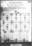 Figure 8: The Dorchester Plan Figure 8: The Dorchester PlanThis system of control and organization was to last less than a decade, however, as the Loyalists found a system of tenure "en fief et seigneurie" to be foreign and irksome to them and petitioned for "free and common socage tenure". With the 1791 Proclamation which established the two provinces of Upper and Lower Canada, they were relieved of such seigneurial obligations. Moreover, the province was divided for parliamentary and militia purposes into 19 original counties running from Glengarry in the east to Essex in the west. Ideally, each county was made up of townships, each township being divided up into 14 concessions, each concession containing 24 lots of 200 acres each (Paterson 1921; Craig, 1963; see Figure 9). Not all the lots were available for settlement, however, as two sevenths of the area of each township was reserved for rental, the revenue so generated being directed to the support of the established church and the operation of the administration. Finally, the original four districts were renamed Eastern, Midland, Home, and Western. Such was the system of organization and administration developed to accommodate the Loyalists following their arrival in the St. Lawrence area, and which was to impart much of the essential character of the region.  Figure 9: The Simcoe Plan (Craig, 1963) Figure 9: The Simcoe Plan (Craig, 1963)Within this framework of administration and control, the initial basic principle guiding the allocation of lands to the Loyalists was that of reward for loyalty and services rendered, and compensation for losses suffered. Accordingly, free land grants were issued in quantities determined by rank:
In 1788, in an attempt at encouraging settlement, the size of the land grants was increased to the following:
With the implementation of the Simcoe Plan in 1792, the incentive of free land was extended more liberally to Loyalists still resident in the new republic - "late Loyalists" as they were to be called. To Simcoe, a flourishing British colony to the north would be the best vindication of the virtues of monarchy and the proof of the failure of republicanism. Thus, in 1792, Simcoe issued a Proclamation to "such as are desirous to settle on the Lands of the Crown in the Province of Upper Canada" (Craig, 1963). On swearing an oath of allegiance to the Crown, settlers were granted land free of charge, other than those costs attendant upon the survey and registration of their properties.  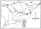
Figures 10a, 10b, 10c, 10d: The Districts of Upper Canada, 1788-1849 With legislation such as this encouraging liberal distribution of land, alienation of Crown Land proceeded apace. Between July, 1792, and December, 1798, some 343,885 acres of land were alienated in the St. Lawrence townships (Cruikshank, 1932-1936, III). But little of this land was actually settled, and the discrepancy between the amount of land alienated and the amount actually settled was to continue to plague the province until the mid-19th century.
Provided with lands and a basic socio-political infrastructure, the Loyalists commenced the process of occupying and developing the area. The first and essential problem was providing a means of livelihood. Initially destitute and dependent upon government storerooms for supplies and utensils (Leavitt, 1879; Mackenzie, 1967), the concern with subsistance was soon replaced by the attempts to develop a staple crop and commercial agriculture. These stages were to be repeated in general outline whenever new "settlement in the bush" was attempted. While the environment of any frontier area may be assessed in terms of such absolutes as geology, topography, climate, soils, and vegetation, the 19th century settler in Ontario was more concerned with certain qualitative evaluations. Thus, the length of the growing season, the occurrence of certain valuable primary products, the frequency of natural hazards, the tractibility of the land, were all indicators of the extent to which a viable existence could be expected. In particular, in the 19th century, much notice was taken of the nature of the vegetation cover for several reasons. Firstly, it was an obstacle to clearing and, therefore, was evaluated in terms of clearing costs; it was also the dominant building and general construction material; its occurrence was also valued as an initial cash crop in the form of lumber and potash, both by-products of the process of clearing; finally, it was considered to be the prime indicator of the potential production of the soil. Thus, explicit instructions to the new settlers advised that:
Using indicators such as these, the pioneer farmer evaluated the land's potential productivity, although elements such as gradient and drainage were also taken into consideration (See Kelly 1970, 1971, 1974). Once his land had been either selected or allocated, the pioneer proceeded to "chop, log, burn, fence and put in crop" as many acres as possible. The actual working of the land so cleared was difficult and it was noted that:
While the main enterprise of clearing the forest and preparing the land for wheat production progressed, vegetables were planted as an auxilliary crop and aid given to other pioneers "upon the principle of reciprocity which must always exist in a new settlement". Eventually, a generally formalized regimen for settling the bush was to emerge in the 19th century:
In this way, the settler could be expected to clear and bring into production between five and ten acres of land each year, depending upon his resources, the nature of the land, and his expertise and techniques. Thus, in eight to ten years, the pioneer could progress from a "settlement in the bush" to the stage of an "old cleared farm" (Jones, 1946; this is shown in Figure 11). Further, while general subsistance continued as part of the economic objective, a production of 15-30 bushels per acre on an expanding cleared acreage eventually resulted in surpluses which could be directed to the developing market system. 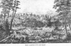 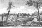
Figures 11a, 11b, 11c: Views of the Development of an Improved Farm (British Farmers' Guide to Ontario) This was the model of economic development that the Loyalists were to experience following their arrival in theThousand Islands region in 1784. By July 2 of that year, Captain Sherwood was able to report that:
Furthermore, the 2,000 people distributed throughout the St. Lawrence townships had cleared 609 acres of land, over 39 acres of it by the 182 settlers in Elizabethtown (Jackson, 1953). Each year, this acreage of cleared land was increased and the land put under crops of winter wheat, oats, barley, rye, corn, peas, potatoes, and miscellaneous vegetables. Initially, there was little livestock but oxen, cows, swine, and poultry increased as the settlement prospered. Despite the temporary setback of 1789, the "Hungry Year" (Leavitt, 1879), the young colony continued to progress rapidly to a state of self-sufficiency and even surplus. By 1794, Kingston shipped 12,823 bushels of wheat, 896 bushels of flour, and 83 barrels of middlings to Montreal while a further 1,624, bushels of wheat and 3,596 barrels of flour were shipped to the garrisons of the area (Jones, 1946). This may be taken as an indication of the developing surplus, a surplus to which the townships of Leeds contributed. A major deficiency was the absence of milling facilities and the dependence upon the government mill at Cataraqui. With the granting of milling privileges to Sir John Johnston and Capt. Joel Stone on the eastern and western banks of the Gananoque River respectively, this problem was alleviated (Mackenzie, 1967, 1973). A unique development in the area was the establishment of the Lansdowne Iron Works at Furnace Falls (Lyndhurst) which, by 1801, was producing a ton of cast and 400 lbs. of wrought per day (Leavitt, 1879). While destroyed by fire in 1811, this early enterprise helped to make the colony less dependent upon support for many of the essential products needed by a pioneer society. The initial nucleus of settlement in Leeds county at Elizabethtown had been expanded with the surveying of Front of Leeds and Lansdowne, and Escotte in 1788, the Front of Yonge in 1794, and Pittsburgh township in Frontenac county in 1789. But while the lands were surveyed and granted, much of the development constituted mere "paper settlement" as the extensive tracts issued to military and other Loyalist claimants continued to be unoccupied. Thus, fifteen years after being opened for settlement, Leeds and Lansdowne had a population of only 125 men, women, and children (Mackenzie, 1973). But, despite much absentee landlordism and land speculation, the population of the area, as that of the province as a whole, continued to grow. From the approximately 6,000 men, women, and children estimated to have been in the province in the early 1780's the population had increased to approximately 70,000 at the outbreak of the War of 1812 (Craig, 1963). Similarly, Elizabethtown's 182 people in 1784 had increased to 2,200 by 1812 and the townships fronting onto the St. Lawrence in the Thousand Islands region must have been approximately 4,000 (Mackenzie, 1973). Patrick Campbell, a traveller through the region in 1791, commented on the narrow strip of improved land along the shores of the St. Lawrence and observed that the Loyalists had effected as much improvement in a generation as had the French in a hundred years of occupying the area (Campbell, 1937). By the time of the War of 1812, therefore, a distinct phase in the development of the Thousand Islands region had come to a close and the transition from frontier zone to agricultural region was well in progress.
The survey, allocation of lands and initial settlement was also initiated in this period on the American side of the St. Lawrence. Thus, in 1784, treaties were signed with the local Indian tribes and, in 1785, the State Land Commissioners were ordered to divide the St. Lawrence shore into ten towns or townships. These were laid out in two tiers of five facing the townships laid out on the Canadian side from Osnabruck to Elizabethtown (Leete, 1929). Each town consisted of 64,000 acres with lots one mile square and with the reservation of lands for roads, schools and other institutions. In contrast to the Canadian side, however, the lands here were to be distributed to potential settlers by sale and, in the majority of cases, through the intermediary of a speculator, developer, or capitalist. Only the latter could afford to purchase the complete townships which were offered for sale although every fourth township was reserved for sale in individual lots to men of lesser means. Thus, one Alexander Macomb, acquired the Ten Towns at auction in New York in 1787 and in the next four years also acquired much of the rest of upper New York state. While these holdings were later to be transferred to other speculators for their eventual development, the point is that on the American side of the St. Lawrence, it was speculators such as these who performed the role played by the British government in Upper Canada. That is, they too induced settlement by encouraging roads and clearings, and sponsoring mills and roads (Jackson, 1953; Durant and Pierce, 1878; Hough, 1853). In the early years of the American settlement along the St. Lawrence, the presence of a British fort at Oswegatchie did much to retard the development there. But with the withdrawal of the British following the Jay Treaty of 1796, the area became available for settlement with the chief motivating force being one enterprising individual, Nathan Ford. The latter erected a saw and grist mills and by 1798 there were ten farms in the Town of Oswegatchie (Hough, 1853). Ford was convinced of the need for improvement in transport in general, and of establishing a link with the Mohawk Valley in particular.
While some settlers on the Canadian side of the river were also attracted to the opportunities offered by the Ford settlement at Oswegatchie, his opinion of their worth reflects the frontier tensions of the day:
As on the Canadian side of the river, the first years of settlement witnessed a pre-occupation with the needs of subsistence and a carving of a livelihood out of the northern forests. A good indication of the growing productivity of the area is that in the first eleven months following the opening of the grist mill at Oswegatchie in 1798, some 3,954 bushels of wheat and 1,820 bushels of corn were processed there (Hough, 1853). But from Ford's settlement to Lake Ontario, the forest was virtually continuous although settlement was progressing in the interior townships (Jackson, 1953). The most flourishing settlement was the village of Brownville, a small community of a dozen homes clustered around a mill site and on the road to Port Putnam (Cape Vincent) which maintained a ferry service to Kingston (Hough, 1853; Casler, 1906). Between these two settlements, there were few breaks in the forest. By the turn of the century, however, the federal census could report 589 males, 455 females, and 32 slaves and servants throughout the townships along the St. Lawrence. With continued progress and development, the separate counties of St. Lawrence and Jefferson were established in 1802 and 1805 respectively (Jackson, 1953).
Commenting on the significance of the War of 1812, Ryerson observed:
While the claim that the Loyalists no longer constituted a "controlling class" in upper Canadian society may be questioned, there can be no doubt that increased immigration from the United Kingdom diminished the demographic dominance of the Loyalists in the colony. It will be shown, however, that in the Thousand Islands region in particular, their significance survived. Moreover, the War of 1812 may be taken as clearly marking the transition from the initial stage of establishing a colony de novo to the next of developing a viable economic and social infrastructure. This was particularly the case for the littoral townships abutting onto the St. Lawrence - Lake Ontario strand. While the essential cultural attributes continue to be those of the Loyalist heritage, the dominant concern during the 1815-1850 period was the nurturing of a viable economy and community. The growth in population, the increased involvement in a wheat staple, and the continued improvement of transport and marketing facilities were all part of this process.
One of the alarming features of the War of 1812 had been the recognition that of an estimated population of 70,000 at the outbreak of that conflict, 60 percent were immigrants from the United States, 20 per cent were of Loyalist origin and the remaining 20 per cent had immigrated directly from the British Isles. To remedy this feared vulnerability to American invasion, a change in emphasis in the immigration policy was instituted. No longer were settlers from the United States wooed but rather, the new policy was to induce members of disbanded military groups and population of "loyal stock" from the British Isles. These new settlers were directed to the vulnerable areas of the St. Lawrence counties and the Rideau Corridor with the front townships of the Thousand Islands region being little affected. However, the more recently opened interior townships experienced the grafting of military and "Scotch line" elements into the earlier Loyalist nucleus (Mackenzie, 1967; Lower, 1922; Cowan, 1967; Craig, 1963). With these initiatives on the part of the colonial government, together with ongoing demographic growth in the older areas, the population of Leeds county continued to increase during this period:
(Gourlay, 1822; Census of Canada). While much of this growth may be related to the expansion of the settled area into the interior townships, a certain measure of infilling in the older settled areas should also be noted. The generous land grants to the Loyalists, while being a reward for past services, had not been a policy of active stimulation of occupation and improvement of the lands. In consequence, it was estimated by 1824, that of eight million acres of land granted by the Crown throughout the province, only three million were actually occupied and, of this, only 500,000 acres were actually being cultivated (Craig, 1963). In the ensuing period much land formerly held by speculators and absentee owners in the old townships was made available for settlement. Moreover, both Crown and clergy reserves, which had been withheld from settlement and which accounted for two sevenths of the area of each township, were opened for development and their lands allocated to settlers (Paterson, 1922; Gates, 1968; Wilson, 1968). With these developments, therefore, the demographic pattern reveals an overall population increase, a greater density of population and a general infilling of the available lots. With regard to the Thousand Islands themselves, they continued to be withheld from settlement at this time. Gourlay noted the presence of some settlers on both Grand Isle and Grindstone Islands and commented:
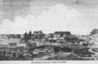
  Figures 12a,
12b: Views of Frontier Settlements (Bartlett) Figures 12a,
12b: Views of Frontier Settlements (Bartlett)The "Mississauguas of the Bay of Quinte" who originally held claim to these islands were moved from the Belleville-Kingston-Gananoque district in 1826-27 and relocated on Grape Island in the Bay of Quinte. While they had ceded their right to the lands adjoining the St. Lawrence in the late 18th century, it was not until 1856 that they transferred their claim to the islands above Prescott to the government (Below Prescott, the islands continued to be held by the St. Regis band). Several of the larger islands had been granted, leased, or held under Indian titles, but the majority continued to be unoccupied into the latter part of the 19th century. Writing in 1880, Hough commented that:
By the close of the 19th century, their disposition to private owners was to be accompanied by a new stage in their development and utilization.
As formerly reserved lands became available for settlement, new occupiers entered upon the cycle of clearing and improving and to some extent, therefore, recapitulated the Loyalist experience of a generation earlier. Furthermore, those who settled as part of the post-War of 1812 programme also benefitted from a degree of government support and sponsorship during the first years of breaking in the land. Others had the possibility of supplementing their initial meagre production by labouring on neighbouring improved farms throughout the area or hiring out to the various lumbercamps or construction works. Finally, the market system was by this date better organized to take such by-products of the clearing process as lumber, potash, and pearlash, so allowing an early cash flow. Elsewhere, in the older lots, the continued progress of clearing had extended the productive area of each farm unit and, therefore, the surplus available for sale. Farm economies thus became involved in commercial production, specializing in the dominant staple, winter wheat (Kelly, 1971). The President of the Agricultural Society of Upper Canada made reference to this speciality in his annual address in 1846:
This does not mean that wheat was the only crop grown but rather, because of market factors, it was the chief one sold. By 1851, therefore, the major crops grown throughout Ontario were as follows:
(Census of Canada, 1851). Leeds county revealed the same pattern of specialization:
(Census of Canada, 1851). That is, 26 per cent of the total acreage under crops in the county (110,633) was devoted to wheat, 15 per cent to oats and 5 per cent to peas. The remaining 50 per cent was under such crops as turnips, carrots, potatoes, clover, beans, hops, hay, flax and others. At the level of the individual farm, the average acreage per farm under wheat was less than 10 acres, while oats and peas each commanded less then five acres. Furthermore, despite the significant regional variation in environment throughout the region, this does not appear to have been accompanied by variations in agricultural specialization. All of the local townships reveal the same degree of concentration in the triad of the contemporary Ontario agriculture: wheat, oats and peas. While the acreage of wheat continued to increase into the 1860's, this period marks the apogee of this particular speciality, with its demise being the dominant feature of the agriculture of Ontario in the second half of the century. Pests such as the wheat midge and Hessian fly, the spread of stem-rust, the loss of colonial preferences, and the opening of new grain lands in the western United States all served to weaken the local pre-occupation with the grain staple (Jones, 1946). Moreover, while the prevailing wheat-fallow-wheat rotation minimized the length of time land was idle, it depleted the soil rapidly and has been referred to as "skinning" or "mining" (Jones, 1946; Kelly, 1971, 1974). In consequence, areas of long standing wheat production experienced falling yields and the Thousand Island townships shared in this experience:
In the second half of the 19th century, farmers turned increasingly to a mixed farming and livestock enterprise. Thousand Islands townships were favoured in this trend by the presence of markets for livestock in the lumbercamps to the rear and access to the burgeoning urban markets for meat and dairy products in the eastern United States (Jones, 1946). Furthermore, the clay lands of the Frontenac Axis, while being unsuited to the production of grain crops were amenable to pasture. As early as 1851, Leeds county was the second largest producer of both cheese and butter in the province and by 1871, of the 323 cheese factories in the province, 21 were located in this county. This was the specialization, therefore, which was to dominate the agricultural economy of the Thousand Islands area in the second half of the century (Jones, 1946).
During the first half of the 19th century, the dominant concern of the economy of the Thousand Islands region was agriculture, with some lumbering in the interior townships. But while diversification was occurring, of the 8,430 individuals classified into 314 different occupations in the 1851 census, 3,258 (39 percent) were farmers, 2,930 (35 percent) were labourers, 242 (3 percent) were shoemakers and 237 (3 percent) were carpenters. The remaining 20 percent were distributed among the 310 other occupations, with none having more than a hundred people assigned to them. Nucleation of settlement was progressing as several service and market centres emerged throughout the region, with Brockville and Gananoque dominating (Smith, 1849). In 1822, Gourlay reported that Brockville consisted of 64 houses and stores, "a place of considerable trade, it being the outlet of a rich, extensive and well settled country back" (Gourlay, 1822, I). He further noted the presence of wharfs, blacksmiths, carpentry works, tanning works, harness and saddle makers, and grist and saw mills. Located as it was in the well settled and prosperous township of Elizabethtown, it continued to function as a local market and service centre for the surrounding agricultural population, while its St. Lawrence connections favoured its participation in transportation and forwarding activities. By 1851, its population had grown to 3,236 people with some 814 families in this, the dominant urban centre of the region (Census of Canada, 1851). Gourlay noted that Gananoque was somewhat of a lesser settlement, "the number of houses small, one of which is two storeys", but possessing two grist mills, two saw mills, a hatter and two retail stores (Gourlay, 1822, I). The continued growth of the community was assured because of the significant power site at the falls of the Gananoque, its harbour and involvement in the river traffic and its function as a crossing point of the river Gananoque by the Kingston-Montreal road. By the 1830's, Gananoque became a leading milling and manufacturing centre for the region and the McDonald mills handled wheat from both Upper Canada and the United States with a capacity of 250 barrels a day, the largest in the province, supplying 25 percent of the flour received at Montreal (Leavitt 1879). Other activities included a foundry, pail factory, fulling and carding mills, lumbering activities, and a clothing factory. By the second half of the century, the "booster" literature was to promise the rise of the town to the position of being the "Birmingham" of Canada. Much of the general progress on both the Canadian and American sides of the St. Lawrence was closely related to the improvement in the system of transport. While a road linking Kingston with Montreal had been effected by 1796, such was the quality of these early roads that, apart from local short-distance traffic, the water route of the St. Lawrence was preferred. Bateaux, Durham boats, schooners, and rafts dominated here into the early 19th century, although steam navigation was introduced to the upper St. Lawrence soon after the War of 1812. By mid-century, the canalization of the rapids of the St. Lawrence and the advent of rail to Ogdensburg and Cape Vincent in the 1840's all served to improve the region's connections with the outside world and generally stimulated traffic through the area. The development of tourism in the Thousand Islands region in the second half of the 19th century was intimately related to this improved accessibility (Glasebrook; 1938, Creighton, 1956; Mcllwraith, 1970).
During this period, the American side of the Thousand Islands region experienced the same general economic trends as the neighbouring Canadian area, but in terms of population growth it was to experience a significant quickening of immigration, settlement and development. The resulting general population trend may be summarized as follows:
(Jackson, 1953). Unlike the Canadian side which had experienced a general re-examination of its open immigration policy following the War of 1812, upper New York experienced continued growth. Initially, the development of the area was somewhat constrained by the perceived infertility of the area and lure of the lands to the west which had become more accessible with such transport innovations as the Erie Canal. Many of those who did choose to settle in the St. Lawrence and Jefferson area were from New England, lower New York, and eastern Pennsylvania, with some Scots from Upper Canada also being attracted to the area (Cowan, 1967; Durant and Pierce, 1878; Hough, 1853). But if the population continued to grow, the clearings were not as extensive as those along the Canadian shore, except at such centres as Ogdensburg, Alexandria, French Creek, and Gravelly Point (Cape Vincent). A contemporary traveller records his impressions of one such clearing:
Surrounding these pockets of clearings were extensive areas of uncleared lands, in particular, areas of swamp and granite throughout the Precambrian outcrop to the west and south. But unlike the Canadian experience, those lands that were acquired were actually settled and developed and the American side was not characterised by the "paper settlement" of the Canadian side. By the 1850's, the densities of the townships in Jefferson and St. Lawrence counties averaged 50 people per square mile with none of the towns having less than 30 per square mile (Jackson, 1953). The highest densities were to be found back in the interior townships because of good road communications with the Mohawk to the south, while those fronting onto the St. Lawrence continued to be less developed. This was noted by a traveller along the St. Lawrence in 1855:
As on the Canadian side of the St. Lawrence, commercial agriculture initially concentrated on wheat as the major cash crop. However, because of good connections with outside urban markets and because of the early advent of railroad links with New York and New England, the area's specialization switched early from the wheat staple to livestock and dairying. As with the Canadian farms, competition from western wheat lands, the ravages of pests and blights, and decreasing yields because of prodigal practices in the past, all favoured the change in emphasis. But, whereas in Leeds county, wheat fell from 25 percent of the acreage in 1851 to 12 percent in 1871, in Jefferson county the same period saw a decline from 9 percent to 6 percent. (Jackson, 1953). Bby 1850, therefore, the American section of the Thousand Islands region had also embarked upon a significant change in emphasis in its agricultural economy. The Landscape [Top] The landscape of the Thousand Islands region contains material relics of the previous three hundred years of European occupancy. The events, processes, and experiences which made up the history of the area may be partially reconstructed from the imprint which man has made upon the landscape. To this extent, therefore, the landscape is not merely to be appreciated for its aesthetic qualities but may also be interpreted as a resource for the better understanding of the social history of the region.
The system of survey was intended to facilitate the decision, allocation, and settlement of the lands being opened up for settlement. It did more than that, however; it imparted a geometry to the landscape of the region with generally rectangular farm lots, arranged in tiers of concessions, separated by a regularized grid of roads, all within rectangular townships of generally standard size. But while Ontario has several survey systems, throughout the Thousand Islands region of the province, the standard survey system applied was the Single Front System (Whitson, 1906; Weaver, 1962, 1968; Gentilcore, 1969; Gentilcore and Donkin, 1973). The first step consisted of running a base line parallel to the river, with the surplus being recorded as "Broken Front" or "Gore". Next, the side lines of the township were surveyed, followed by the running of the concession lines. As the latter were being surveyed, lots of 200 or 120 acres were marked off at regular intervals along the front of each concession (Gentilcore and Donkin, 1973).  Figure 13: The Single Front System (Gentilcore and Donlin,
1973) Figure 13: The Single Front System (Gentilcore and Donlin,
1973)As road allowances were surveyed between each concession and along every fifth lot, a fine network of transport was provided, although the actual road system which developed was frequently incomplete as some were left unopened, while in other cases they were interrupted by lakes, etc... . Nevertheless, the grid of roads is one of the characteristic features of the area. With such a groundplan, the evolving pattern of occupancy took on a distinctive linear pattern. Initially, a concession would be featured by a row of farmsteads at regular intervals along a road. Also, because the clearing process concentrated initially along the lands closest to the road and farmstead, land use would generally decrease in intensity away from the road to a rear woodlot. With population increase, subdivision of lots often occurred. Longitudinal splits resulted in an increased frequency of adjacent farm lots; horizontal splits into front and rear hundreds gave rise to rows of farmsteads facing each other across interior concession roads. Gentilcore has noted the universality and significance of the contribution of a survey to the character of Ontario:
An element of the landscape that picks out the delineations of the survey system, reflects the rigours of the clearing process, and which is also of some interest in its own right, is the fence style. Fencing property was a fundamental prerequisite in occupying and developing land and constituted a considerable investment in both time and material for the enclosure of property. It is not surprising, therefore, that the materials used were both ubiquitous and inexpensive with the products of the clearing process being utilized wherever possible. So rapid was this establishment of fence lines that the linearity of the Upper Canadian landscape became a topic referred to by several visitors in the 19th century. Thus in 1832, Catharine Parr Traill recorded her early perceptions of the Ontario landscape and noted:
Several styles of fences and boundary markers may be observed throughout the Thousand Islands region. Once the initial clearing of underbrush and chopping of the forest cover had been completed, the progress towards an improved farm unit required the "stumping" of the land. As long as stumps remained in the land, they presented obstacles to regular and deep ploughing. Their removal and deposition along the fringes of field units produced a distinctive fence style that is a particularly vivid demonstration of the process of carving out of farmsteads from the forest. 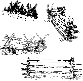 Figure 14: Fence Farms (Source: P.M. Ennals) Figure 14: Fence Farms (Source: P.M. Ennals)Many of the settlers of eastern Ontario were from areas in the Celtic fringe of the Old World where stone fences were widespread. The new environment offered them the opportunity of transferring this element, if not in the stylized form of their homelands. In both the glacial till lands and the Frontenac axis, the clearing process required the removal of rocks from the land, and their deposition along the edges of the productive area minimized the loss of land and also served as a boundary. Where these were mere linear heaps of stones than walls, they were often topped by either rail or stump fences. The clearing process also produced a ubiquitous material, lumber, which was also used as fencing material. Cedar, in particular, was utilized because of its durability and ease of splitting into rails. Two particular styles appear to have been dominant. Fences utilize either the tripod of posts for the upper support while the end of the rail rested on the ground, or two parallel upright posts between which the rails were alternated sometimes with rock spacers. Both fence styles may be linear, although they are sometimes serpentine. Another characteristic of the rail fence was that they were easily disassembled if necessary for farm management purposes.
As the agricultural economy of Upper Canada progressed, the improvement of the farmstead was accompanied by the construction of the "cathedrals of the rural landscape", the barns for the storage of grain and, later the accommodation of livestock. The styles of barns throughout the region vary and reveal changing economic specialities, the cultural background of the settlers, and personal preferences and predilections. Two-bay barns were primarily associated with grain-producing enterprises and not with livestock endeavours, and are, therefore, associated with the earlier stages of Ontario agriculture. Its distinctive feature is the central thrashing floor with two storage bays on either side, one a granary and one a combined stable and storage. In its typical form, this barn is set directly on the ground without a stone foundation storey and is rather smaller than other barn styles. The siding/clapboarding may be either vertical or horizontal.  Two-bay barn Two-bay barn
Figures 15a, 15b, 15c, 15d: Barn Types (Harris and Warkentin, 1974) The raised two-bay barn has the features of the two-bay barn with the additional element of a foundation storey which is utilized for wintering and stabling of animals. It better suited the requirements of farms in the latter half of the 19th century as livestock became more important. After 1880, the gable roof is frequently replaced by the gambrel roof which allows more usable space in the upper areas of the barn. While essentially similar to the two-bay barn, the threshing or drive floor may be at one end and a small stabling area at the other end. Generally, this form was constructed of lighter timber rather than the lumber of the earlier farms. The most characteristic barn of southern Ontario, the bank barn, consists of a lower storey devoted to livestock, while the upper level is the crop storage area. While this barn sometimes makes use of the local topography to allow access on one side, elsewhere, a ramp is constructed to the elevated central doorway. While other barn styles may be identified in areas of specialized crops, distinctive cultural groups of idiosyncratic developments, it has been claimed that over 90 percent of Ontario's barns may be classified in one or other of these categories (Ennals, 1972).
A basic necessity for each family settling the area was the provision of some form of shelter. In all cases, the form of the building reflected the need for protection from the elements, provision of accommodation for domestic functions, contemporary tastes and styles and, especially in areas of developing settlement, levels of affluence and financial resources. The landscape of any area, therefore, contains architectural elements which may be interpreted in terms of the cultural history of the area. The architectural requirements and preferences in a specific period frequently became so distinctive and dominant that they may be assigned standard characteristics and also the period of most frequent occurrence. Thus, throughout the Thousand Islands region, various variations on two standard themes may be recognized. Firstly, in the early part of the 19th century, the Greek Revival exerted a major influence upon domestic architecture and generated several forms of what has come to be called the "Ontario Loyalist House". The degree of conformity to the ideal form by the various vernacular representations reveals variations in wealth, personal preferences, etc., but the core idea is easily identifiable. Secondly, the latter half of the 19th century is represented architecturally by the neo-Gothic revival represented in the Victorian excesses of gingerbread and Italianate form and trimmings. Constructed of brick, a building material being more widely distributed during the latter half of the 19th century, or frame, of particular note in this style are the ginger bread/framework decorations of gables, verandas, and other elements (Adamson, 1963; Gowans, 1966; Blake, 1969). 

(A) Shanty and (B) Log house, which were common in pioneer areas before Confederation.
Figure 16: House Types (Harris and Warkentin, 1974) (Drawings by Peter Ennals) Contemporary illustrations and accounts of the first stage of pioneer occupancy suggest that the log house was the first form of residence constructed by the pioneers. A ubiquitous material and a relatively simple form of construction, both lent themselves to this mode. While later forms were quite elaborate, it may be questioned whether the initial shelters were mere shanties and even tents, forms which did not endure and which we can but imagine. The log house itself varied from simple one-room units to more elaborate one-and-a-half and two-storey structures. While several of these survive in the interior townships, because of the longer period of occupancy, few survive along the St. Lawrence littoral although relics may be identified in outbuildings adjoining more modern structures. With the progress of the agricultural enterprise and the increasing dependence upon commercial agriculture, farm improvement was often accompanied by another sign of affluence, a more substantial house unit. The date at which this stage was reached may be identified generally by the style of the building constructed, the style in vogue at the time. The lavishness, scale, and style of the construction again may be interpreted in terms of the general social standing of the occupier. The use of logs has already been referred to as an example of use of a ubiquitous material. Regional housing styles frequently reflect the material available in the environment for fabrication, and to some extent the nature of the material contributes much to the character of the product. While logs were a common initial material, they were later followed by various lumber and timber frame constructions or else of stone. In the study area, the contrast between the Precambrian outcrops and those of the Ordovician strata is reflected in the materials used. The distance travelled by local building materials was not great and most houses were made of the material at hand. With the improvement of transport, the diffusion of more standardized building materials, such as brick, became more common.
Other elements in the landscape also reveal past processes of settlement. Potash kettles, stumping machines, fish-net driers, ice houses, sugar shacks, mills, and cemetaries are all scattered throughout the landscape as vestigial remains of a past society. In the study of Grenadier Island, Jane Allen referred to the contribution which such relics make in understanding the past:
When all these items are considered together they allow a reconstruction of the material setting of the past which complements the written record. What follows is a listing and examination of the 17th-18th century cartographic representations of the Thousand Islands region. These materials constitute valuable sources of early conceptualizations of the area, and also a record of early developments within the region. The following is a preliminary listing of French cartographic references to the area:
|
||||||||||||||||||||||||||||||||||||||||||||||||||||||||||||||||||||||||||||||||||||||||||||||||||||||||||||||||||||||||||||||||||||||||||||||||||||||
|
|
||||||||||||||||||||||||||||||||||||||||||||||||||||||||||||||||||||||||||||||||||||||||||||||||||||||||||||||||||||||||||||||||||||||||||||||||||||||


 Figure 6
 Raised two-bay barn
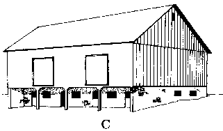 Pennsylvania barn
 Bank barn